Knife Edge Trail, Katahdin,
Baxter State Park, Maine

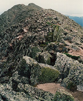
Caption: From left, Pamola Peak (4,902 feet elev.), followed by the narrow col, Pamola Cleft, and Chimney Peak. If you look close over that first little knob at right, you can see the trail winding up to the next knob.
Hairiest, scariest trail I've ever hiked, is the 1.1-mile Knife Edge Trail on Mount Katahdin in Baxter State Park, Maine. Some sections are 12 inches to 2 feet wide, and the drop on either side, straight down 2,000 feet or more.
Stephen Clark's book, "Katahdin, A Guide to Baxter State Park & Katahdin," is THE book you want when you're hiking in Baxter. I got a copy in 1988. Clark says there's no equal to this glacially-formed feature in the Appalachian Mountains. He's also right that, from afar, the Knife Edge, a glacial aręte, does look like a fin on a dinosaur's back:

Caption: Another view of Knife Edge, showing the drop, taken from the edge of Baxter Peak's summit. That's South Peak (5,240 feet elev.) at far right.
It took me four trips up there (4-hour drive one-way from my home) to get a day with relatively good weather to attempt it (Aug. 5, 1997), and, even then, I got caught in a fast-moving rain storm about halfway across. It's one of the worst places to be in a lightning storm or high winds, because you're above treeline on a narrow, rocky path and drops on either side of thousands of feet, and then there's wet rocks.
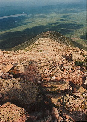
Caption: Heading toward Katahdin's South Peak (5,240 feet elev.).
My worst experience on that trip: trying to find a way down in The Chimney area. It is a very steep descent. Had to carefully go off the trail, and it took me about 45 minutes to find a safe way down, because I wasn't tall enough to lower myself over edge and drop to the rocks below. Using rope, I lowered my pack (don't take a pack unless it's a SMALL day pack) down, though.
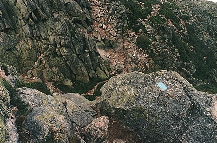
Caption: Looking over edge from Chimney Peak down into narrow col named Pamola Cleft. The narrow ribbon of brown in lower center between the vegetation, is the trail. A cutoff trail veers to the right up a flank of Pamola at the edge of the opposite ledge. The technical descent into a deep couloir, known as the Chimney, follows the trail toward the left. It descends to Chimney Pond, but requires ropes and other mountaineering gear. To ascend Pamola Peak on the trail, you have to climb up sheer rock faces.
And then, once I was safely down in the narrow col, Pamola Cleft, with shaky legs, I couldn't get up the other side to summit Pamola, so had to take a detour around the front side to link up with the Helon Taylor Trail (3.2 miles), and, my, what a boulder-strewn experience that was.
Caption: Heading down the boulder field of Helon Taylor Trail on Pamola Peak flank. That's part of Basin Ponds at top left.
Think I got back to the Roaring Brook Campsite around 8 or 9 p.m., hiking the last few miles by headlamp. Exhausted and thoroughly drenched, and injured. In the rain, I'd slipped on a wet rock on Helon and clipped my head on a branch while pitching forward.
In my opinion, the safe way to do Knife Edge is with buddies, and some rope to lower packs (unless you're taller than 6 feet), or ascend it from Helon Taylor Trail, rather than descend it from Baxter Peak (5,267 feet elev.) summit, like I did with some people I met at a conference. Their faster hiking gaits left me behind. We ascended Katahdin from Chimney Pond via the Cathedral Trail (1.6 miles), and wow, what views, but a struggle in places, because it's a boulder climb.
Here's some photos I took along Chimney Pond Trail and Cathedral Trail:
Speaking of views, they're spectacular from the Knife Edge Trail:

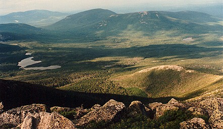
Caption: View from Knife Edge Trail into South Basin, Chimney Pond and Basin Ponds in distance. That ridge at left center, is Hamlin Ridge; mountain flank at right center is Pamola's, down which the Dudley Trail descends.
And, from Helon Taylor Trail on flank of Pamola Peak:
Caption: View of Basin Pond from Helon Taylor Trail on Pamola Peak.


Last updated, June 5, 2006. Copyright © 1998-2006 Terry L. Karkos
pikagnome@midmaine.com
<BGSOUND SRC="wanderer.mid">